Once upon a River
by Diane Setterfield
The above map shows the Swan Inn at Radcot, but if you click the "Defra" button it will show the whole area used in this lovely book -
from The Swan (top right where the road crosses the river) to Buscot (bottom left) -
and the rather appropriate heading on the map is "MAGIC"!
The Magic of the book is not the artificial human supposed magic of witches and spells
but rather the natural magic of the river
and its interaction with those who live by it and use it.
I have been almost implicitly invited to add my thoughts on the book by the author herself.
She says:
"There is one website I navigated a thousand times while writing this book
and which was invaluable to me. It takes you on a journey through space and time, along the river.
Where Thames Smooth Waters Glide was created by John Eade and he maintains it with dedication.
If you can't get to the Thames itself, this website is the next best thing."
So who am I to argue with that?
The book is of course an interpretation of the river:
This river, which is and is not the Thames ...
Indeed if you are reading the book in a boat do not be mislead by its geography.
Upstream sometimes means downstream!
In a way the book is a story about stories ...
One of the central stories concerns Quietly, the ghostly ferryman, who appears when
there is danger of drowning and either helps people to the bank (if their time has not yet come)
or ferries them over to the other side.
Having said all that my concern here is not with the book as literary accomplishment
(much as I appreciate it) but with its relationship with the actual places of the Thames
as they were in the past.
So here I can provide illustrations (many from Taunt himself) to throw light
on the doings and places of the book:
HENRY TAUNT
When is it set? Well that is a little flexible but mainly defined by the life of Henry Taunt
the photographer (1842-1922) known in the book as Henry Daunt.
(What an inspired name change! Taunt was "dauntless" in his pursuit of his photography - and his
cumbersome equipment and long exposures offer far more dramatic possibilities than the casual mobile photo).
So say 1880. Having said that, Rita the village nurse was born in the Convent Hospital of the Nuns at
Godstow which would have meant something around 400 years earlier. This is not history!
1878: Below Marsh Mills (Marsh Lock above Henley) by Henry Taunt. An especially precious photograph because the character leaning on the gate is Henry Taunt himself -

Below Marsh Mills with Henry Taunt by Henry Taunt, 1878
© Oxfordshire County Council Photographic Archive;
Taunt's photograph of Trewsbury Mead by which the unconscious Henry Daunt was identified in the book.
It showed a corner of a field, an ash tree, and not a lot else
"I've seen prettier pictures", someone said.
"It wants a church spire or a thatched cottage", said another.
"It don't seem to be a photograph of anything exactly", said a third.
"Trewsbury Mead", said Joe, the only one to recognise it.
 Thames Head, Trewsbury Mead, by Henry Taunt
Take Trewsbury Mead, for instance. That photograph, do you remember?
The one they were so quick to dismiss, because it wasn't picturesque?
An ordinary ash in an ordinary field, they said, and so it appears, but look more closely.
See this indentation in the ground, at the foot of the tree?
See how it is the beginning of a furrow, shallow, narrow and unremarkable, that runs
away from the tree and out of the picture altogether?
See here, in the dip where something catches the light and shows a few ragged patches
of silver in the grey shades of muddy soil? Those bright marks are water ...
This section relates to the discussion about the sources of a river which can be found here, and in particular Professor Huxley's contribution:
1869: "The source of the Thames comes from nowhere; it turns round in a circle."
The Saturday Review, part of a Report of a Lecture by Professor Huxley -
... The source is said to be at Thames Head,
but the sources are countless, and are all round the basin of the Thames,
in the springs that rise at the edge of the hills
that enclose it.
The springs led him to consider the rain, snow, and hail
clear enough for a child to understand, and interesting enough for a man to
listen to. At last, he passed into almost eloquence as he showed how the sea
supplies the air with the vapour of water, how the vapour of water passes into
rain, how the rain supplies the springs, and the springs the river, and how the
river in its turn supplies the sea.
"The source of the Thames comes from nowhere; it turns round in a circle."
The Swan Hotel at Radcot
The central location of the book is the Swan Hotel at Radcot Bridge

Swan Hotel, Radcot taken by Henry Taunt, 1903
© Oxfordshire County Council Photographic Archive; HT09058
I can't find a Henry Taunt photograph of the Swan from the river.
This is as it was in 2016:

Swan Hotel, Radcot from the river, 2016
1875: Radcot Old Bridge, Henry Taunt -

Radcot Old Bridge, Henry Taunt, 1875
© Oxfordshire County Council Photographic Archive;HT01160
Nobody really knows how the tradition of storytelling started at the Swan,
but it might have to do with the Battle of Radcot Bridge.
In 1387, five hundred years before the night this story began,
two great armies met at Radcot Bridge ...
1387: The Battle of Radcot Bridge. December 19th. In the fifteenth century manuscript of the Chronicle of Jean Froissart

The Battle of Radcot Bridge, 1387.
In 1386, a group of nobles, jealous of the
influence on King Richard of certain advisors who were outside the royal circle,
forced themselves on the king as a governing council. The following year,
however, encouraged by Michael de la Pole, Robert de Vere and others, Richard
managed to reassert his authority, but afterwards there was an armed uprising
by the Duke of Gloucester, the Earl of Arundel, the Earl of Warwick and others
who accused these same advisors of treason.
There was a military encounter,
known as the Battle of Radcot Bridge, between these forces and
Robert de Vere, who had determined to escape to Ireland.
It is said that the central arch of the bridge was demolished as a trap in the
course of this battle, and later rebuilt.
My original comment on the above picture was
"the battlements in the distance make one suspect that he had never been to Radcot!"
However - treat historic pictures with respect even if you think they are false!
A Time Team excavation of Radcot
found evidence, a lot of evidence, of various historic buildings here, suggesting a Roman Villa,
a stone Norman Keep, and a Civil War earthworks used in the assault on Radcot House.
The Norman Keep may well have been demolished before 1386 -
for after all if not one would have expected it to figure in the battle!
The position of these buildings was on what is now still called "The Garrison" to the north of the bridge.
Here is the Time Team's impression of it:
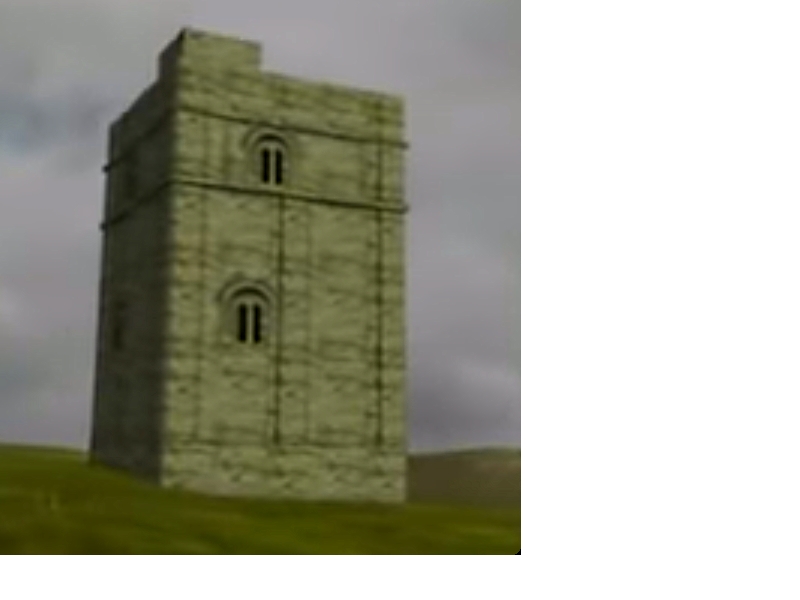
Radcot Keep according to Time Team
1600s: Camden -
This Isis, when it hath passed a small part of Wilshire,
no sooner is entred into Oxfordshire but, presently being kept in and restrained with Rodcot bridge,
passeth by Bablac, where Sir Richard Vere that most puissant Earle of Oxford,
Marquese of Dublin and Duke of Ireland, who as he stood in most high favour and
authority with King Richard the Second, so he was as much envied of the Nobles,
taught us (as one said) that no power is alwaies powerfull.
Who being disconfited in a skirmish by the Nobles and constrained to take the river and swim over,
found the Catastrophe of his fortune and subversion of his State.
For immediately he fled his country and died distressed in exile.
Of whom the Poet in his Mariage of Tame and Isis made these verses:
Heere Vere, well knowen by badge of savage Boore,
While man-hood shames to yeeld, yet strives againe
Stout hart may not, restrained by wisdomes lore.
Whiles shield resounds by doubled blowes a-maine,
And helmet rings about his eares, is faine
The streame to take. The river, glad therefore,
His guest tooke safe, and set him safe on shore.
Quietly was at work even then:
"His guest took safe, and set him safe on shore." ...
Devil's Weir
The accident which triggers the events of the book is said to be at Devil's Weir.
I identify that at what is now Eaton Footbridge. It was previously a weir.
The evidence comes from Taunt himself:
I recollect one winter in passing this very weir, when lying on my back in the boat to get through, scraping a fair amount of skin off my nose and face through contact with the bridge whilst going under. In winter there is very little fall.
"Very little fall" means a lot of current and difficulty getting under the beam.

Below Eaton Weir, Henry W Taunt, 1883
© Oxfordshire County Council Photographic Archive; HT4275

Hart's Weir, 1859.
Notice the punt going stern first (the till or deck being at the front,
Oxford style) It is thought this
is so that the punt is not swamped when shooting such weirs - see
the site of Medley Weir.
1871: Taunt says the fall here was 3 feet -
[ See the print of the weir in 1859 above - you can see that as the river rises the clearance beneath the bridge might become problematic. ]
1880: An account of Hart's Weir and how to manage a paddle and rymer weir -
Then straight on again the river runs, past more remains of old weirs,
past Eaton Hastings till Hart's Weir is reached,
the approach to which is half covered with rushes.
Those who tow must be careful at Hart's Weir.
The fall is the highest met with; the stream is consequently strong
and will test the strength of your line; it is best to double it if long enough.
The bank too is awkward. ...
Let us take this opportunity of describing an Upper Thames weir, and how to get through it.
It is an institution unknown below Oxford except in conjunction with a lock,
but in the parts we are exploring a weir often exists by itself.
It forms a breakwater right across the stream.
There is a bridge running along the top, on which you must take your stand;
then one by one you must pull up the paddles which run between the rymers.
These rymers are fixed at regular intervals in the sill, which is under water; they too must be removed.
You then find you have a clear space through which to pass your boat.
Two men should stay in the boat; one should take the towing-line and mount the bridge,
pulling the boat gently towards him, those on board taking care to keep it off the sides.
The stream runs swiftly through the opening, so sometimes considerable care is required.
When the boat is half way through, the tow-rope is passed to the man on the bank,
who pulls the head gently round, whilst those in the boat keep her clear.
Do not ever attempt to pull the boat completely through from the bank
or it is sure to stick against the side beams.
With care and a little practice there is no great difficulty in negotiating a weir,
though sometimes the rymers give some trouble,
the weight of the water keeping them tight in their places.
Give them a push upstream before attempting to raise them.
In coming down the work is easier, as the boat goes with instead of against the stream,
but great care must be taken to keep the boat clear.
Another danger is that unless you bend low your head may strike the bridge.
BUSCOT and BRANDY ISLAND
1859: Edward Loveden's family sold the estate to Robert Tertius Campbell newly returned from Australia. He bought the villages of Buscot and Easton Hastings with their total population of some 3500. And he set about turning this run down estate into a marvel of modern Victorian Industry.
1870s: The factory on the Left bank above Buscot Lock -

Campbell's Buscot Factory.
Campbell decided to produce alcohol from sugar
beet, so first
he thoroughly drained the land, then he built a twenty acre reservoir, then
three large water wheel driven pumps to fill it, one at Buscot
and two at Eaton (see above).
With the land now properly irrigated Campbell grew his beet and collected it with a light railway with three locomotives, taking it to his distillery on the Left bank just above Buscot Lock. He also manufactured oil cake, gas, fertilizer and vitriol. At one point his alcohol was sold to France at 2/6d a gallon!
1879: The entire enterprise was scrapped because it no longer made a profit - and now we are left with a few otherwise puzzling remains. There is still a pump on the Left bank above Buscot Lock which supplies water to the reservoir and this is on what was known as Brandy Island.
1876: Map showing Buscot Industrialisation: the "Cake" Factory (oil), Berkshire Distillery, Gas works (private), the Manure Works (artificial)
and the Vitriol (sulphuric acid) Works.
[ This was all removed - or being removed by 1883 ] -
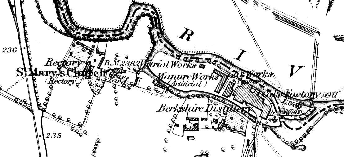
1876 Map of Buscot
KELMSCOTT
It is interesting that the most obvious feature of Kelmscott at this time
does not appear in the book - Kelmscott Manor was William Morris' little place in the Country.
However one of his friends has very obviously influenced the plot - indeed more or less
provided elements of it; Dante Gabriel Rossetti in 1871 wrote "Down Stream"
while punting on the Thames near Kelmscott in late July.
[ a little morality tale - boy takes girl boating ... ; girl has baby ; girl commits suicide. ]
Rosetti told William Bell Scott -
The verses are a little ballad or song or something made in a punt on the river, not a very poetic style of locomotion. It's rather out of my usual way, made aiming at the sort of popular view that Tennyson perhaps alone succeeds in taking.
Between Holmscote and Hurstcote
The river-reaches wind,
The whispering trees accept the breeze,
The ripple's cool and kind:
With love low-whispered 'twixt the shores,
With rippling laughters gay,
With white arms bared to ply the oars,
On last year's first of May.

drawn Ford Madox Brown
Engraved by C M Jenkin
Between Holmscote and Hurstcote
The river's brimmed with rain,
Through close-met banks and parted banks
Now near now far again:
With parting tears caressed to smiles,
With meeting promised soon,
With every sweet vow that beguiles,
On last year's first of June.
Between Holmscote and Hurstcote
The river's flecked with foam,
'Neath shuddering clouds that hang in shrouds
And lost winds wild for home:
With infant wailings at the breast,
With homeless steps astray,
With wanderings shuddering tow'rds one rest
On this year's first of May.
Between Holmscote and Hurstcote
The summer river flows
With doubled flight of moons by night
And lilies' deep repose:
With lo! beneath the moon's white stare
A white face not the moon,
With lilies meshed in tangled hair,
On this year's first of June.

Between Holmscote and Hurstcote
A troth was given and riven,
From heart's trust grew one life to two,
Two lost lives cry to Heaven:
With banks spread calm to meet the sky,
With meadows newly mowed,
The harvest-paths of glad July,
The sweet school-children's road.
Rosetti was very pleased with the two illustrations: He wrote to Ford Madox Brown -
it is like a tenderer kind of Hogarth and seems to me much the most successful of your book illustrations. . . . The little one is very pretty too.
[ My opinion of this is censored as not relevant to the book! See Kelmscott page ]
Taunt's Boat
Henry Taunt on his floating studio near Oxford, Oxfordshire, 1895.
Henry Taunt is pictured on the houseboat which he used for river photography with a lady,
probably his close friend Fanny Miles. (Photo by English Heritage/Heritage Images/Getty Images)

And now, dear reader, the story is over. It is time for you to cross the bridge once more
and return to the world you came from.
This river, which is and is not the Thames, must continue flowing without you.
You have haunted here long enough, and besides, surely you have rivers of your own to attend to?