EA PENTON HOOK LOCK Downstream graph
EA PENTON HOOK LOCK Upstream graph
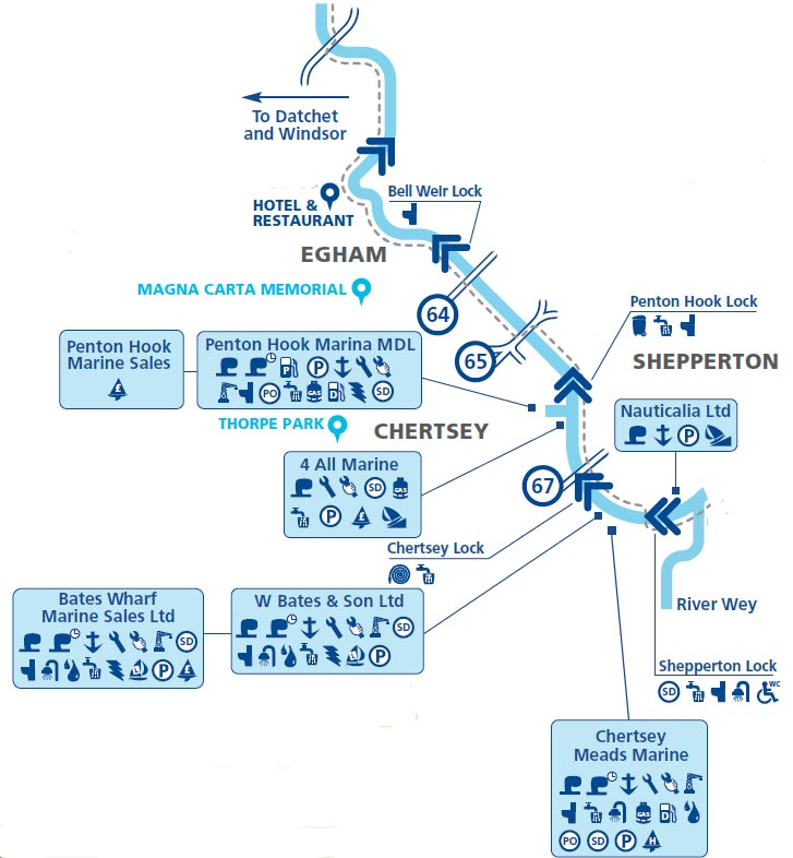
Penton Hook Lock
Right Bank lock, tel: 01784 452657, length 266'8", width: 24'10"
Penton Hook Lock Island
Left bank in lock, linked to weir which is linked to Penton Hook IslandPenton Hook Island
Staines Amateur Regatta [27 July 2019]
Staines Amateur Regatta. 8:30am to 6:00pm. This annual regatta takes place on a 500m course downstream from Wheatsheaf Lane [Riverbank Flats]
finishing at Silvery Sands.
This event is free for spectators, who enjoy watching the racing at the temporary licensed bar at Silvery Sands.
There is also an enclosure area at the finish line, barbecue, fresh sandwiches, teas, cakes, and ice cream.
[ See 1903 below ]
1992: Skyscan's Aerial View of Penton Hook in The Secret Thames -

Skyscan's Aerial View of Penton Hook.
The two islands are, nearest, Penton Lock Island, linked by a weir to
the large wooded Penton Hook Island
beyond, top right is Penton Hook Marina
1774: Floods kept cutting through the narrow neck of land where the lock now is.
Raising a bank at Pentanhook to prevent the floods cutting through
1798:-
A barge has passed through the breach, which may be totally carried away by the next flood to the great injury of the navigation westward
1803: Tatham – the neck only fifty yards across.
1809: Rennie suggested a lock here.
1815: Penton Hook Lock opened. The basin of the lock gave great trouble to
the engineers; it was found almost impossible to prevent the water from flooding it.
There was at first no weir.
1843: Puntwreck! Bentley's Miscellany -
THE ADVENTURES OF MR. LEDBURY AND HIS FRIEND, JACK JOHNSON.
BY ALBERT SMITH.
Those acquainted with the course of the Thames from London to Windsor may remember that
Penton Hook is a piece of land between Staines and Laleham, which turns the river
into a narrow and sudden curve, cut off from the shore by the lock;
whilst the main body of water flows round it with brawling rapidity on a sharp descent,
forming a natural weir.
Some strong piles are fixed at the head of the rapid, to keep the large craft from being drawn into the current,
and, about half way round the Hook, it gives off a small stream, called the Abbey river,
which formerly washed the foundations of Chertsey monastery,
one of the most powerful mitred religious houses of its time.
The worn-out boat, carrying the two fugitives, was now being drifted by the turbulent river towards this point;
and the roar of the water, as it dashed between the head-piles of the lock, became fearfully louder and louder.
Johnson kept at the head of the boat, or rather at whichever part of it went first,
as it was whirled about in the eddies, and attempted to throw a little more light around them
from the miserable candle in the old lantern they had brought with them.
And Morris, anticipating the swamping of the punt, which appeared inevitable, had risen from his seat;
and, having thrown off his cloak, prepared to reach the land as he best might,
when the catastrophe should arrive.
Sometimes the boat neared the shore so closely that its edge grated against the rough stones of the embankment;
but, before either of them could hold on, it had turned round again, and was once more
in the middle of the deep and rapid channel.
Johnson had plainly discerned the dark forms of the head-piles stretching across the river,
towards which they were now hurrying, and in another instant the punt was borne against the foremost one
with a violent shock, that threw them both from their feet, and partly stove in the side,
at the same time knocking down the lantern, and extinguishing the light;
but they immediately recovered their position, and endeavoured to cling to the iron-work of the standards,
and arrest the progress of the boat.
The power of the water was, however, too much for them; and, turning round the side of the piles,
the punt rushed with fearful violence down the fall, and into the centre of the rapids below the weir,
the water pouring in everywhere through the crevices of its battered sides.
Swift as had been their passage before, it was now increased tenfold, as they grated successively
over the stones of the shallows, or glided swiftly onward in the deep water,
amidst the masses of ice which were floating everywhere on the surface of the current. ...
[ They survived! ]
1846: Weir built.
1848:-
The lock keeper’s son, Stephen Taylor planted the vine and fruit trees, sunk the well and built the dairy, besides papering the parlour
[Sounds like a Victorian Music Hall cue for a song ...]
1852: A trespassers' sign was erected -
The idle and disorderly of Staines and Laleham are frequenting the lock island on Sundays
1859: The Thames, Mr & Mrs Hall
The river proceeds hence between low banks, which are frequently
inundated during winter, until we reach the lock at "Penty-Hook" —
Penton-Hook — an artificial passage by which boats are enabled to avoid
a "long round" of a mile or so. But he who voyages for pleasure will
find this ancient passage very desirable: it is generally an entire solitude;
water-birds revel here; butterflies are always numerous; the
Thames trout is seldom absent from its tiny breaks and waterfalls; and
the Abbey river is one of its tributaries, suggestive of memories when
the monks of Chertsey had here their productive fisheries, which kept
their ponds and preserves continually full.
This retired and tranquil
branch of our dear river is in high favour with the angler; and perhaps
there is no single nook of the Thames, from its rise to its fall, where he
can receive so large a recompence of quiet pleasure. Does he "scrape"
for gudgeon? — here he will find a dozen "pitches", each of which yields
enough for a day. Will he try his skill among the roach and dace,
baiting with a single gentle a "No.12" hook mounted on a single hair,
and a somewhat heavy float — for the stream hereabouts is deep and
rapid? — he is either a poor craftsman, or will be singularly unfortunate,
if he do not basket his ten dozen before he issues from the bend into the
main current. Does he covet the "big" chub? — let him throw his
mimic grub under any one of those overhanging willows, and the
chances are he will hook one of more than three pounds' weight. But,
especially — is he a barbel fisher, and has the luck to have Galloway
aiding and assisting his sport? — he is sure to catch more than he will
like to carry home, if he has to walk from the bank to the railway.
Galloway, who lives close to Chertsey — or, as he will tell you, "Chersy"
— bridge, is one of the best fishermen on the Thames, and if any day in
his company be not a good day, the fault will not be his; for he knows
not only every pitch, but every stone of the river between his own
immediate locality and a few miles above it and below it. He is not
only an experienced and intelligent, but a most obliging and "pains-taking"
guide and counsellor, and seems always to consider that ample
sport is ever a part of his contract, — so, as we have said, if the evening
bring disappointment, the cause has been beyond his control But if a
neophyte visit the Thames in search of sport, whose line is strong
enough, and hook big enough, to snare and land a Severn salmon, — if
his shot are swan-shot, and his float a pretty toy, and his rod bends like
a reed in a storm, or is as stiff and straight as a "poplar tree" — what
then can Galloway do?— what but shrug his shoulders, gently hint that
the water is too clear or too thick for sport, and grumble "under breath"
a wish that such brutal tackle were in "Norroway". And to this heavy
affliction he is often doomed; while the "angler" seeks the train with a
light load, and growls his discontent against the liberality of the bountiful
Father, who has only refused reward to a bungler in the art.
Let the true angler, who knows his art and loves it, spend a day with
Galloway at Penty-Hook, and we assure him of a day's enjoyment such
as he will rarely find elsewhere, or in other company; for Galloway is
full of Story such as the fisherman likes to hear and tell.
1870: Penton Hook Lock, Henry Taunt -

Penton Hook Lock, Henry Taunt,1870
© Oxfordshire County Council Photographic Archive; HT1478
1880: William Morris, Putney to Kelmscot -
Wednesday Aug 11th 1880
[William Morris] fished at 6.a.m. caught one gudgeon and one small dace,
WM, DM & Price bathed also RCG at 8.30.
Started at 10 o'clock: towed on without incident to Penton Hook Lock.
Hove to just above the Lock for dinner at 1.30; weather very fine and hot.
DM & WM shied at their food.
Started again about 2.30
towed on to Runnymede calling at Staines for soda water, ginger beer & milk.
1881: George Leslie, "Our River" -
Penton Hook has a beauty of its own; the willows grow gracefully and rather thin, reminding one a little of the landscapes in early Italian pictures. There is nothing remarkable in the way of scenery below here until you reach Richmond, the situation of which is naturally so grand that I believe no amount of building could spoil it.
1889: Jerome K Jerome -
George got the line right after a while, and
towed us steadily on to Penton Hook.
There we discussed the important question of camping.
We had decided to sleep on board that night,
and we had either to lay up just about there, or go on
past Staines.
It seemed early to think about shutting up then, however, with the sun
still in the heavens, and we settled to push straight on for Runnymead, three
and a half miles further, a quiet wooded part of the river, and where there is
good shelter. -
We all wished, however, afterward that we had
stopped at Penton Hook. Three or four
miles up stream is a trifle, early in the morning, but
it is a weary pull at the end of a long day.
You take no interest in the scenery during these last few miles.
You do not chat and laugh. Every half-mile you cover seems like
two. You can hardly believe you are only
where you are, and you are convinced that the map must be wrong; and, when you
have trudged along for what seems to you at least ten miles, and still the lock
is not in sight, you begin to seriously fear that somebody must have sneaked
it, and run off with it.
1901, The Thames Illustrated by John Leland-
Penton Hook, or as it is often pronounced "Penty" Hook, is a little higher up the river [from Laleham].
At this point the stream makes a sudden sweep round a great horse-shoe curve, on the Surrey side,
which the lock cuts at its base, leaving a green and well-wooded island between.
The banks are green and sedgy, and the quiet waters of the long curve have a restful charm, not broken by the passage
of steamboats and launches, which makes them pleasant to linger along.
1903 - 1913: Penton Camp Club - a Memory of Penton Hook. A memory shared by Su Knight on Jan 26th, 2007.
The Penton Camp Club started in about 1903.
Its members included the Manager of Martin's Bank, London, the manager of the Drury Lane Theatre and many other rich men.
They would come by train to Staines, the old station at the entrance to Two Rivers Shopping Centre,
walk to the bridge and be taken from there by the owner of the large hotel that stood on the left bank opposite the Swan to the weir -
the right bank opposite Penton Hook Lock Island.
One weekend there was a disaster, the camp was flooded and the local residents came to the aid of the stranded campers.
In July 1903 it was suggested by the campers that a local association was formed,
which stretched from the Fishing Temple to the camp. This club lasted for many years.
Each year there would be a magnificent ball in London and in the summer a regatta at Silvery Sands including punting and diving.
The last regatta was advertised for 1914 but had to be cancelled due to the war.
In 1921 it was decided that funds that remained in the kitty would be given to the lock keeper
to supply a memorial on the lock island to those members who were killed in the war. I have yet to find it.

Silvery Sands c1898 Copyright Chertsey Museum
1909: Penton Hook Lock rebuilt.
1920: Fred Thacker – I have never heard what particular station
Dickens intended by “Plashwater Weir Lock” in "Our Mutual Friend".
It seems to me, from internal evidence, that
it was possibly Penton Hook;
though Sunbury, from its proximity to Watersplash Farm, may also
be in the competition. …
1864: Charles Dickens, from "Our Mutual Friend" -
Plashwater Weir-Mill Lock looked tranquil and pretty
on an evening in the summer time. A soft
air stirred the leaves of the fresh green trees and passed like a smoother
shadow over the yielding grass. The
voice of the falling water, like the voices of the sea and wind, was an outer
memory to a contemplative listener.
'Lock, ho! Lock!'
It was an amateur sculler, well up to his work though taking it easily.
The lock-keeper worked at his windlass handles and sluices, to let the sculler in.
the latter stood in his boat, holding on by a boat-hook to
the woodwork at the lock side, waiting for the gates to open.
The creaking lock-gates opened slowly, and the light
boat passed in as soon as there was room enough, and the creaking lock-gates
closed upon it, and it floated low down in the dock between the two sets of
gates, until the water should rise and the second gates should open and let it
out.
The water rose and rose as the sluice poured in,
dispersing the scum which had formed behind the lumbering gates, and sending
the boat up, so that the sculler gradually rose like an apparition against the
light.
But there was the toll to be taken, as the gates
were now complaining and opening.
He tossed it ashore, twisted in a piece of paper,
then rowed past a line of wooden objects by the weir which showed like huge
teetotums standing at rest in the water, and was almost hidden by the drooping
boughs on the Right bank, as he rowed away, keeping out of the opposing current.
1920: Fred Thacker -
Penton Hook Lock is, except Teddington, and perhaps Boulter’s, the largest on the river. The first time I ever saw it was in flood time in the spring of 1910; coming unexpectedly upon handsome old Myhill in charge of it, whom I knew well at far off Hambledon. He was moved hither about 1907-8. I thought he looked more than ever saturnine; having added to his natural air of admiralty a still profounder aspect of austerity with which not the most truculent bargemen of them all would successfully have trifled. He seemed even cosier here than there, surrounded with white crooning doves and little lawns and orchard: Myhill; with whom royalty, they say, would once step ashore and converse.
1934: Penton Hook Lock, Francis Frith -

1934: Penton Hook Lock, Francis Frith
1955: Penton Hook Lock, Francis Frith -

1955: Penton Hook Lock, Francis Frith
Site of Savory’s Weir
1/2 mile above Penton Hook Lock
1761: Rocque’s Map - “Savory’s Weir”
1770: Brindley’s map – “Fisher House”
1920: Fred Thacker – House called “The Fishing Temple”.
The spot was subsequently used as a coaling wharf;
and later still as a charging station
for the Immisch Launches, before they occupied Platt’s Ait.