Lower Hope, PLA - Tidal Thames Recreational Users Guide 2011
Lower Hope from Lower Hope Point to Coalhouse Point
Lower Hope PointLEFT (southeast) bank point on the inside of the turn from Sea Reach into the Lower Hope
Site of Mucking Bight Light
On RIGHT (northwest) bank on the bend
1849: First light here.
1851: Permanent structure built.
1885: Dickens's Dictionary of the Thames -
Mucking Flat Lighthouse, Sea Reach:-
Built of iron upon a hollow pile foundation.
A temporary light was first exhibited from this position in October 1849,
and the present structure was built in 1851.
It is painted black and white in
alternate horizontal bands, and is
connected with the shore by a long footbridge,
also built on piles and coloured white.
The height of the light tower from base to vane is 66 feet,
and its central lamp burns at 40 feet above high water.
The lamp is under occultation once in every half minute, and the apparatus used is
lenticular, giving forth a white beam with red sectors.
A fog bell is sounded during foggy weather.
There are two keepers employed in tending the station,
who, having their dwellings at hand, with coals, light, and furniture provided
for them, and living with their families, have a much more comfortable billet
than their neighbours at Chapman lower down.
Mucking Bight Lighthouse © Mike Millichamp, [adapted] -
Lower Hope Reach is the end of Sea Reach and the limit for sea going tankers.
Mucking Bight or Flats is a mud bank which starts
at Shellhaven and extends up river to Coalhouse Fort.
At 33 miles from London Bridge
Mucking Bight lighthouse was built here on piles in 1851, maintained by two keepers and
connected to the shore by a long footbridge. It was painted in black and white bands
and in 1881 it was raised to 70 feet high and painted red. The 1953 floods and a
collision with a barge in 1954 led to its removal ...
On RIGHT (northwest) bank on the bend, about 1 km inland
Mucking FlatsRIGHT (northwest) bank opposite Lower Hope point
Mucking MarshesRIGHT (northwest) bank behind Mucking Flats
Redham MeadLEFT (southeast) bank upstream of Lower Hope Point
Cliffe CreekLEFT (southeast) bank just downstream of Cliffe Fort.
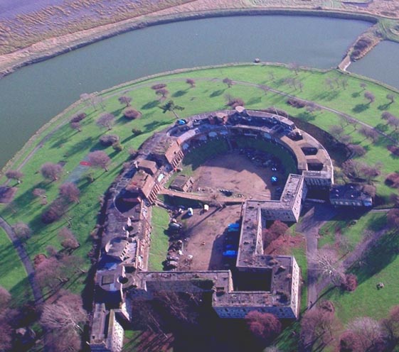
Cliffe FortLEFT (southeast) bank, opposite Coalhouse Fort and just downstream of Coalhouse Point

Cliffe Fort
Old OS Maps showed neither Cliffe Fort nor Coalhouse Fort.
These were militarily sensitive places.
Cliffe Fort website -
Cliffe Fort, near the village of Cliffe on the Hoo peninsula in Kent, was built in the mid-nineteenth century
as a defence against the invasion of London via the Thames estuary.
The fort is derelict and not open to the public, although you can walk around outside the walls.
Since 1999, it has been owned by Robert Brett & Sons Ltd, whose aggregates works adjoin it.
It is still impressive, and notable as the site of an early guided weapon system: the Brennan torpedo.
The Irish-Australian Louis Brennan invented the guided torpedo which was the "state of the art" coastal defence weapon
from 1887 to 1903. The torpedo had two propellers, rotated by wires which were attached to winding engines
on the shore station and which played out after the torpedo was fired.
By varying the speed at which the two wires were extracted, the torpedo could be steered to the left or right
by an operator on the shore.
RIGHT (northwest) bank, opposite Cliffe Fort and just downstream of Coalhouse Point
Coalhouse Fort website

Coalhouse Fort
[ I've read enough Hornblower to know you always attack such a fort from the rear. This apparently always took foreign gunners by surprise. It looks as though someone belatedly noticed that and added some rear defences! ]
